

In the realm of urban development and planning, the past often whispers stories that shape the present and influence the future. Historic preservation is not just about maintaining old buildings; it’s about understanding the cultural, social, and architectural contexts that define a community's identity. As cities evolve, integrating historical sites into modern plans requires innovative approaches that honor the past while embracing progress. One of the most transformative tools in this endeavor is 3D reconstruction, offering a dynamic way to visualize and contextualize historical sites within contemporary landscapes.
The Power of 3D Reconstruction in Historic Preservation
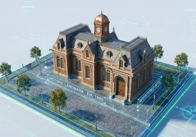
3D reconstruction brings historical sites to life, allowing planners, developers, and the public to experience these locations in immersive and interactive ways. By creating detailed 3D models, we can visualize how historical buildings and districts once looked, understand their spatial relationships, and assess their potential impact on modern development projects. This technology is invaluable for:
Visualization: 3D models provide a clear, accurate representation of historical structures, aiding in understanding their original form and condition.
Contextualization: By integrating historical sites into modern urban plans, 3D models allow stakeholders to see how the past and present can coexist and complement each other.
Engagement: Interactive 3D models and virtual tours can engage the public, fostering a sense of connection to their local history and encouraging support for preservation efforts.
Integrating GIS Mapping Systems and 3D Map Rendering
Geographic Information Services (GIS) play a crucial role in historic preservation by providing a spatial framework for understanding and managing historical resources. When combined with 3D map rendering, GIS data can be used to create detailed visualizations that show the relationship between historical sites and their surrounding environment. This is particularly useful for:
GIS Urban Planning: Integrating historical data into urban planning processes ensures that preservation efforts are considered alongside other development priorities.
Interactive Map for Website: An interactive map that incorporates historical data, 3D models, and GIS mapping system information can be a powerful tool for educating the public and promoting heritage tourism.

Applications in Modern Planning
The integration of 3D reconstruction and GIS technology has several practical applications in modern urban planning:
Impact Assessment: 3D models can be used to assess the potential impact of new developments on historical sites, ensuring that preservation concerns are addressed early in the planning process.
Adaptive Reuse: By visualizing how historical buildings can be adapted for modern uses, 3D models can help developers find creative solutions that preserve the character of a site while meeting contemporary needs.
Public Engagement: Interactive 3D models and virtual reality experiences can be used to engage the public in the planning process, gathering feedback and building consensus around preservation initiatives.
Incorporating 3D reconstruction into historic preservation efforts offers a powerful way to bridge the gap between the past and the present. By leveraging technologies like geographic information services, GIS mapping system, GIS urban planning, 3D map rendering, and interactive maps, we can ensure that historical sites are not only preserved but also celebrated as integral parts of our modern communities. At Flyer View Group, LLC, we understand the importance of telling your story through data, maps, motion, and graphics. We offer comprehensive services to help communities and developers integrate historical preservation into their urban planning initiatives. Contact us today to learn more about how our expertise can bring your vision to life and explore our portfolio to see how we've helped others connect with their history.