

In the realm of economic development, the ability to visualize and analyze geographic data has always been paramount. Aerial imagery, in particular, has undergone a remarkable evolution, transforming from a rudimentary tool to a sophisticated asset that provides invaluable insights for urban planners, investors, and policymakers alike. At Flyer View Group, we've witnessed and participated in this evolution, constantly adapting our services to meet the changing needs of our clients.
From Basic Photos to Advanced Data
In the early days, aerial imagery consisted primarily of simple photographs taken from aircraft. While these images provided a bird's-eye view of an area, their utility was limited by their lack of precision and analytical capabilities. Today, advancements in technology have led to the development of high-resolution digital imagery, 3D map rendering, and sophisticated geographic information services (GIS). These tools allow us to extract detailed information about land use, infrastructure, and environmental conditions, providing a comprehensive understanding of a region's economic potential.
The Rise of GIS Mapping System
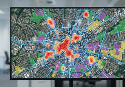
One of the most significant developments in aerial imagery has been the integration with GIS mapping system. GIS allows users to overlay aerial imagery with other data layers, such as demographic information, zoning regulations, and transportation networks. This integration enables powerful spatial analysis, helping economic development professionals identify optimal locations for new businesses, assess the impact of proposed developments, and develop targeted marketing strategies.
Applications in GIS Urban Planning
Aerial imagery and GIS are now essential tools for GIS urban planning. They can be used to create interactive map for website, assess the suitability of land for development, monitor construction progress, and evaluate the environmental impact of urban growth. By providing a visual representation of urban areas, aerial imagery helps stakeholders make informed decisions about land use, transportation, and infrastructure investments.

Enhancing Economic Development Strategies
The evolution of aerial imagery has had a profound impact on economic development strategies. With the ability to access and analyze vast amounts of geographic data, economic development professionals can now make more informed decisions, attract new businesses, and promote sustainable growth. Whether it's identifying potential development sites, assessing market opportunities, or monitoring infrastructure investments, aerial imagery provides a valuable tool for enhancing economic prosperity.
From basic photographs to interactive maps, aerial imagery has come a long way. At Flyer View Group, LLC, we are committed to staying at the forefront of this evolution, providing our clients with the most advanced tools and services available. Our comprehensive suite of services, including Community Profiles, vertical aerial imagery, and GIS/Mapping Services, are designed to help you unlock the economic potential of your community. Contact us today to learn more about how we can help you tell your story through data, maps, motion, and graphics. Explore our website to discover how our content creation and web-marketing platforms can further enhance your economic development initiatives.