

Understanding future growth patterns is crucial for effective community planning and sustainable development. Geographic Information Systems (GIS) offer powerful tools for modeling these patterns, allowing stakeholders to identify potential development hot spots and make informed decisions. By leveraging GIS capabilities, communities can proactively manage growth, optimize resource allocation, and mitigate potential challenges.
The Power of GIS in Urban Planning
GIS is more than just a mapping tool; it's a sophisticated system that integrates spatial data with analytical capabilities. In the context of urban planning, GIS can analyze various factors influencing growth, such as population density, transportation networks, zoning regulations, environmental constraints, and economic indicators. This analysis enables planners to create predictive models that visualize future development scenarios.
Identifying Growth Hot Spots With GIS
Several GIS techniques can be employed to pinpoint areas likely to experience significant growth:
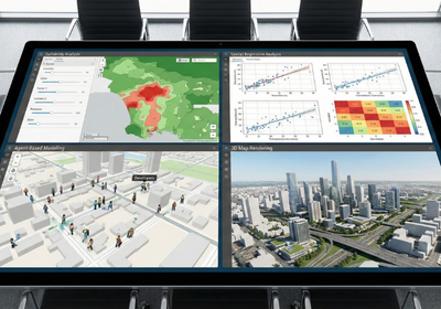
Suitability Analysis: This method overlays various spatial layers representing factors that attract or deter development. By assigning weights to each factor based on its relative importance, GIS can generate a suitability map highlighting areas most conducive to growth.
Spatial Regression Analysis: This statistical technique examines the relationship between growth patterns and various predictor variables. By identifying statistically significant correlations, GIS can forecast future growth based on these relationships.
Agent-Based Modeling: This approach simulates the behavior of individual actors (e.g., developers, residents) within a community. By modeling their interactions and decision-making processes, GIS can predict how growth will unfold over time.
3D Map Rendering: Visualizing future development scenarios in three dimensions provides a more intuitive understanding of the potential impacts of growth. 3D map rendering can showcase proposed building heights, infrastructure changes, and landscape modifications.

Benefits of GIS-Based Growth Modeling
Informed Decision-Making: GIS provides evidence-based insights that support strategic planning and policy development.
Proactive Resource Allocation: By anticipating future growth, communities can allocate resources (e.g., infrastructure, services) efficiently.
Stakeholder Engagement: Interactive maps for websites and visualizations facilitate communication and collaboration among stakeholders.
Environmental Protection: GIS can identify environmentally sensitive areas and guide development away from these locations.
Economic Development: By understanding growth patterns, communities can attract investment and promote sustainable economic development.
GIS empowers communities to proactively shape their future. By leveraging its analytical and visualization capabilities, stakeholders can make informed decisions, optimize resource allocation, and create sustainable, vibrant places to live and work. At Flyer View Group, LLC, we understand the power of data-driven storytelling. We offer comprehensive GIS/Mapping Services, design data-rich infographics, and provide interactive map solutions to help you visualize and communicate your community's growth potential. Contact us today to discover how we can help you tell your story through data, maps, motion, and graphics. Explore our Community Profiles and Web-Marketing & Proposal Builder Platforms to see how we can support your economic development goals.