
Claim Your Free 3D Rendering
Stop pitching with spreadsheets. Start pitching with vision.
Turn your city’s GIS data into a high-end 3D rendering that attracts investors and simplifies council approvals. Claim your free custom rendering today.

Most Economic Development Pitches Die in the Data
You have the "usable stuff" — spreadsheets, GIS layers, and zoning maps — but stakeholders often fail to see the true potential of a site. When your data is presented in a jarring or overly complex format, it creates friction in decision-making and slows down the approval process. We solve this by distilling vast datasets into clear, powerful visuals that highlight growth opportunities rather than technical hurdles. By removing this "visual noise," we ensure your audience remains focused on the vision rather than the complexity of the underlying data.
❌ Hard-to-read wireframes that confuse stakeholders and council members.
❌ Static maps that fail to tell a compelling chronological story.
❌ Missed investment opportunities due to a lack of "visual wow."

High-End Graphic Design Meets Precision Mapping
Flyer View Dynamic Maps bridge the gap between technical GIS data and professional marketing to ensure your city stands out. We take your standard city data and transform it into a cinematic, 3D experience designed specifically for high-stakes boardrooms and public hearings. Our team leverages advanced geographic information services to ensure every asset is not only geographically accurate but also visually stunning. This unique combination allows you to showcase infrastructure and demographics in a format that commands immediate attention and respect.

Presentation Ready
Designed specifically for professional boardrooms and public hearings.

Fully Dynamic
Interactive layers that let you show — not just tell — your city's growth.

Branded for Your City
We match your municipality’s branding for a polished, official look.

Trusted by Cities Across the Country
Our reputation is built on delivering high-impact visual tools to municipalities and development authorities across the United States. We understand the unique pressures of urban planning and the necessity of securing public and private buy-in for large-scale projects. By providing these entities with professional map posters, wall murals, and 3D models, we help them communicate their vision with total confidence. These tools serve as the centerpiece for important community profiles, ensuring critical data points are understood by every viewer.
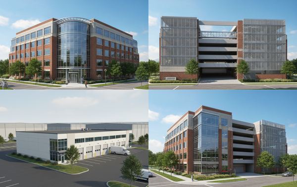
Visualizing Growth with 3D Modeling
Our 3D modeling services take flat geographic data and render it into a realistic environment that stakeholders can fully explore. This immersive perspective allows council members and investors to see the potential impact of a development site long before the first stone is laid. By providing this level of clarity, you eliminate guesswork and build the confidence necessary to secure significant capital commitments for your municipality. These models serve as the centerpiece for your most important community profiles and large-scale public displays.
Clients That Trust Us


see your project in 3D
Our team is ready to help you convert your existing map data into a high-impact asset that drives real-world results for your city. To get started, please fill out the form below to claim your free 3D rendering.